Saving the landscape
London 2012
Text: Meyer, Friederike, Berlin; Schlaich, Christoph, Köln/London
-

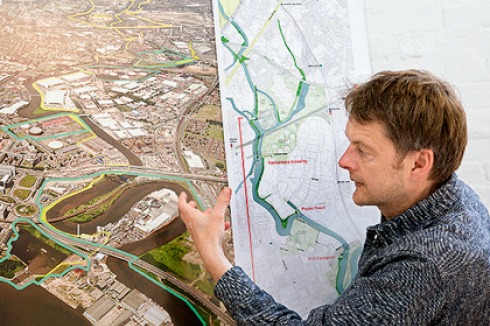
Tom Holbrook
Foto: Torsten Seidel
Tom Holbrook
Foto: Torsten Seidel
-

The River Lea runs three miles through industrial land between the Olympic Park and the Thames estuary. 5th Studio has been preparing plans for the redevelopment of the banks of the Lea River Park since 2006. Tom Holbrook explains how he wants to preserve the coexistence of nature and urban infrastructure, what the Fatwalk is, and why so little “park” is yet visible.
How does the Lea Valley appear today?
The Lea Valley as a whole occupies a huge area, over 4,000 hectares, about 12 times as big as Tempelhofer Feld in Berlin. But it is not as compact and rarely more than 1 km wide. The Lea Valley starts on the edge of the city’s greenbelt and stretches over 26 miles south to where the River Lea flows into the Thames. It accounts for a large portion of London’s ‘Green Grid’. The idea of making this valley a landscape resource for London is almost 70 years old, anchored in Patrick Abercrombie’s London Plan of 1944. The valley is shaped by the systems that support and provision the city. It stores much of London’s drinking water, and its gas. Power cables and one of London’s main sewers run down it. Much of London’s food was once grown, and is now processed here. The river has always been a political boundary: between the Saxons and the Vikings, between different London boroughs. As a ‘no-man’s land’ everything from waste chemicals to explosives have been deposited here – a difficult legacy that we have to deal with.
On the map much of it already looks very green.
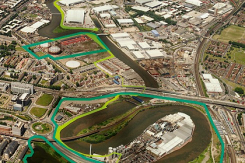
From the air, the northern section, the Upper Lea Valley, really does looks open and natural, but in fact it is one of the oldest artificial landscapes in England. Since the 18th century the river has run in artificial channels. A narrow path follows its banks. Although it is continuous, it often leads past the high retaining banks of huge reservoirs. Many areas can be neither accessed nor seen. The Olympic Park starts at Hackney Marshes and runs on both sides of the river, about 2.5 miles to Stratford High Street. This is a classical park according to the rules of formal art. There are two and a half more river miles until the Lea’s confluence with the Thames – the Lower Lea Valley – and that’s the area we’re working on.
You won the competition for the Design Framework for the Lea River Park in 2006. What did you propose?
Much of this part of the valley is an industrial zone and it will continue to provide jobs. Our first plan was more or less a careful description of the remarkable landscape that already exists. We were interested in distinguishing it from the Olympic Park. It quickly became clear that only a fraction of the money would be available for our park. We do not want to make a tabula rasa, but rather work with what is there, and what is latent in the peripheral and marginal zones. The park should in turn lead development in the river valley, and its development is accordingly planned to run over time – at least 20 years. Various architects and landscape planners are likely to be involved in individual projects.
Was that your idea or the city council’s wishes?
That was our suggestion. While we were working on the design framework, we also applied (together with Latz + Partner, comment of the editors) for the implementation – and we won. So we went on to prepare detailed designs for a first phase – The Fatwalk.
What are its main features?
First of all we want to create links between and to the river’s banks. People who live on either side of the valley have little access to open space. Statistically speaking, each inhabitant of the adjacent residential areas has only a third of the open space recommended for London. The Fatwalk project will run along the riverside through the entire valley and link the planned parks and public open spaces that together will constitute the Lea River Park: Three Mills Green, Mill Meads, Twelvetrees Crescent gasholder site, Poplar River Park, Black Poplar Wood, the Limmo site and the East India Dock Basin. Originally the Fatwalk was scheduled to be completed for the Games, but the money flowed slower than we had expected.
Where did the name Fatwalk originate?
On the one hand our park has to compete with the Olympic brand. On the other hand the area is riddled with footpaths: the “Lea Valley Walk” and “Lea Valley Pathway”. We wanted a name that becomes engraved in people’s minds. Many prominent locations in London have curious names. Rotten Row, for example, is a wonderful bridleway in Hyde Park. The Fatwalk is opportunistic: it fills the area between the banks and the adjacent properties. It’s fat, because it occupies marginal, left-over land and ties in all the paths merging on the site. Incidentally, it’s amusing to hear politicians talk about the “fatwalk”.
I heard that the term Fatwalk describes a path along which carpets were transported in the East India Docks.
That escapes my knowledge. But that’s the whole object, to get people to invent stories about the origin of the name.
How do you intend to design the Fatwalk?
Trees are to be planted: recognisable White Poplars will punctuate the Fatwalk together with various other native and exotic trees creating, or rather reinforcing, the different characters of landscape along the route. Exotic plants are already growing in some areas. They arrived on the ships at the East India Docks in former days and have spread out over the neighbourhood. We will introduce ‘edible landscapes’ wherever we can – to reference the valley’s character as a ‘place of plenty’. We have rescued existing surfaces where we could, and added ‘mats’ of precast concrete elements to mark significant points on the route, augmented with areas of permeable bound gravel and meadows. We don’t consider paths to be necessary on both sides of the river. It’s much more important to use the topography as an orientation aid and make the river the uniting element.
How do you aim to do this?
There is, for example, the “Twelvetrees Crescent” project: a bike lift, stairway and ramp leading from the riverbank onto an old bridge and connecting the Fatwalk with a stretch of existing towpath. That’s what will make the bridge reusable. Then there is the new bridge over the river. The difficulty is that high-voltage cables run on both sides of the river so the bridge responds to this, while forming a belvedere to two very diferent river ‘characters’ – urban and wild, either side of the bridge. Our client, London Thames Gateway Development Corporation has just acquired a 12-metre wide strip of land for the purpose. And finally we are working on the “A13 Crossing” project, a filigree pedestrian and cycle path which runs through the old bridge of an urban motorway which creates a major division in the city, a bridge beneath the bridge, if you like.
Is there a forerunner for the Lea River Park?
The landscape park by Peter Latz in Duisburg is one, although it is not urban. The Highline project in New York is perhaps also a forerunner. But even that one is very different. We looked, of course, at how London has created parks, particularly at Nash’s Regent’s Park, which was established with surrounding urban development. The Lea River Park certainly has unique qualities though.
What role is played by the industrial buildings?
We wanted not only the accessible areas to be seen as a park. Here we’re talking about a borrowed landscape - an ancient topic in English landscape architecture. Only we don’t have any temples and castles as visual stimuli, but industrial buildings. The seemingly endless façade of one of Europe’s most modern waste recycling plant, for example, is almost scenographic. It can become part of the park.
The Lea is still a working river. Do you see a problem for people seeking recreation?
Although the inland waterways authority constructed a new lock for the Olympics, because it wants to intensify the river’s use for freight, the river is in fact infrequently used. Road transport is much cheaper, and the tides which have an influence on the water level on this stretch. Our conception of the park we are keen to increase use of the river as it will animate the park spaces and allow one to read the scale of the waterspace. Whichever way, I don’t see any problem for the park. Horses and bicycles can be rented, picnics enjoyed. The park feels natural, but it isn’t – this juxtaposition is exciting.
As architects you have now spent six years in the field of landscape architecture. What has been your experience?
We have enjoyed the intellectual demands of designing at all registers, from the master concept to the minute details of bridge design. The project has reinforced the fact that the most important prerequisite for effective city planning is communication: negotiations with politicians, engineers, institutions, financiers and property owners. That is a complicated matter, because the people responsible are constantly changing. If the politicians don’t own an idea, it can get lost among other tasks. During the course of the project so much has changed – many of our original clients no longer exist. We find ourselves the only element of continuity in the project.
For many years Berlin has wanted to construct a public footpath on the banks of the Spree in the east of the city. Due to the small-scale administrative structure of its districts and current legislation it is powerless against the interests of the property owners. Do you have similar problems in London?
The London Thames Gateway Development Corporation was empowered to acquire land by compulsory purchase. Of course, the property owners were reluctant to surrender land and utility companies are notoriously anti allowing public access to their property. But the mayors (Ken Livingston and Boris Johnson) have given the plan their support as a regeneration priority. Those are powerful instruments.
What is the relationship of your park to the Olympic Park?
The Olympic Games are a catalyst for the Legacy fringe areas. They have drawn attention to East London. But they have tied up substantial political power and money. That is frustrating. The Lea River Park needs someone with charisma and influence: a champion.
At what stage will the park be ready? When will we be able to cycle along the Fatwalk?
Our three links and their landscapes - Twelvetrees Crescent, Poplar Reach and A13 Crossing - will be ready for the opening of the Olympic Park in Legacy. Then the park will be strong enough to exist as such. But it’s not merely about the 26-mile stretch from north to south, the primary aim is to create a link across the valley for residents, from one neighbourhood to the next. We still have a long way to go before people realise that the Lower Lea Valley is no longer a dangerous wasteland, but a new foreground for London.
Fakten
Architekten
5th Studio Architecture & Urban Propositions, London
Adresse
River Park Ave Staines, Surrey TW18, Vereinigtes Königreich
aus
Bauwelt 24.2012
Artikel als pdf
x
Bauwelt Newsletter
Immer freitags erscheint der Bauwelt-Newsletter mit dem Wichtigsten der Woche: Lesen Sie, worum es in der neuen Ausgabe geht. Außerdem:
- » aktuelle Stellenangebote
- » exklusive Online-Beiträge, Interviews und Bildstrecken
- » Wettbewerbsauslobungen
- » Termine
- » Der Newsletter ist selbstverständlich kostenlos und jederzeit wieder kündbar.
Beispiele, Hinweise: Datenschutz, Analyse, Widerruf


0 Kommentare