Cities in flow
Introduction
Text: Nest, Günter, Berlin; Bertuzzo, Elisa T., Berlin


Cities in flow
Introduction
Text: Nest, Günter, Berlin; Bertuzzo, Elisa T., Berlin
This issue of Stadtbauwelt is meant to incite a debate on urban planning based on the similar geographic und demographic conditions of two megacities and thus going beyond mere rhetorical couplings like “Kolkata-Mumbai-Delhi” that have become popular in megacity research. In an era of climate change and increasing mobility, such conditions can crucially influence the cities’ fate beyond their sheer size.
On the conceptual as well as factual journey between Dhaka (Bangladesh) and Kolkata (the former Calcutta, India) we have practiced a, so to speak, transversal method of observation. The aim has not been to compare facts but to juxtapose them; with the aim of revealing differences rather than explaining them. Thus, Dhaka and Kolkata are not only seen as related cities that are examined in the search for the best methods in dealing with problems. Instead, the cities are examined “cross overly”. In the result, the focus is not on universal assertions but rather on the coexistence of diverse tendencies to be seen in the context of the initial topic of “water”.
Embarking on this experiment, the utopian value that has been ascribed to megacity life especially in the last decade must be called into question. Megacities as promises, as shelters of the most heterogeneous aspirations, as global cities – all these designations share a programmatic, nothing less than ideological inscription promising development and progress in the urban realm. But is that really true? The examples of current urban planning in Dhaka and Kolkata covered in this issue of Stadtbauwelt are far from bolstering such ideas. They rather suggest that it might be wise to uncouple the notions of “development” and “progress” that are much too often used in an undifferentiated manner. The articles of authors contributing perspectives from Europe, South Asia, and the USA illustrate the need for an urban planning that does more than just making sacrifices. Contrary to the Western enthusiasm for informality and “spontaneous” growth planning is more necessary than ever in order to initiate adequate developments.
In which way do two of the biggest cities in South Asia, cities with a similar geographic profile and common cultural heritage, react to the challenges of urban development? What has been their traditional relationship to water, and in which way has it changed? Which legal and illegal uses of water areas do emerge caused by the pressures of urbanisation? And which risks millions of mostly poor inhabitants are exposed to near the water?
Approaching the city, step by step
Imagine that you were standing on a ghat, one of these flights of stairs leading down to the water that are quite common in South Asia. Is it a village ghat or did you reach it from the noisy historic district? Is it devoid of people or is it full of Hindus performing ceremonies at the water’s edge? Are you impressed by a thousand-years-old prayer ceremony, the nearby bustling river port or only by the garbage swimming in the water?
In preparation of this issue, we stepped down diverse ghats in order to photograph and explore the phenomena described by our authors. Beyond the diversity of sensual stimuli that could inspire other stories, this feature typical of South Asian water architecture has incited us to combine thoughts of a philosophical, anthropological, or hydrographical nature with planners’ perspectives. At the first step on the ghat nothing but the river comes to the fore. Reports on the increasing danger of flooding and rapid environmental changes in the fast growing cities of Asia raise questions concerning the safety and control of the water bodies. On the continent of Asia, a wide range of cities can be studied that are subject to different processes of growth and react in quite different ways on the current problems related to water – from Vietnam’s integrative approach in the Mekong Delta, where water ways and land routes are developed simultaneously and a “zero waste” agriculture is sought, to the mainly technologically underpinned water parks in urban China in which nearness to the water is often only suggested, right down to the Ganges Delta, which is split between India and Bangladesh, where the increasing displacement of centuries-old water habitats by residential or industrial development causes a rapidly growing number of extreme floods.
Numerous myths testify to the fact that the emergence of new civilisations has always coincided with the regulation and control of the water. They are evocative of the fact that the challenges waterfront settlements – in Asia and elsewhere – are confronted with are far from being new phenomena. In fact, for millennia there has been an ongoing strained relationship between urban growth, progress, landscape, and water. In Asia, the rivers had been traditionally used for agricultural means but – contrary to Europe - their embankments had been developed only rarely. This was caused by the wide and – geologically – rather young river beds with highly fluctuant flow rates due to the monsoon season that is a typical feature of the Asian climate. In the result, cities were founded near rivers but in safe distance from them. Today, civil engineers especially from China and India, who draw their inspiration from international examples, have a try at “appropriating” the river fronts and embankments in the hope of realising a higher quality of life in the densely populated cores of their cities.
Tradition and reality
The water reflects the shape of two cities whose historic evolution has been quite different though it is based on the same motif, as Mahbub Rahman and Partha Das explain (p22 et seq.). Dhaka as well as Kolkata owe their foundation alongside two rivers, respectively the Buriganga and Hooghly Rivers, to the fact that these rivers are directly linked to the Indian Ocean. The two port cities thrived due to the river trade – Dhaka as a staple market of Muslim merchants and, from 1610, as the capital of Bengal, the richest province of the Mughal Empire, while Kolkata, which had been established as a British outpost, later became the capital of the entire British Raj. In both cities, mostly docks and warehouses were planned in close proximity to the water while residential buildings stood somewhat removed to be protected against the waters’ forces during the monsoon time. Imposing buildings with access to the water were only erected by the Mughals, foreign conquerors and Armenian, Dutch, French, and British merchants. Today, the buildings – landmarks and cultural heritage – are threatened as they are often poorly maintained and stand empty. At the other end of the social system the traditional practices in appropriating the river banks are subject to radical changes too. For example, Bangladesh’s “Water Gypsies” (see p. 58) who temporarily settled before the gates of Dhaka, at the confluence of the Buriganga and Tongi Rivers, at the beginning of the dry season for centuries, have increasingly left their traditional style of life.
In the light of these facts, it comes as a relief that the ritual importance of water typical of South Asia seems to survive despite ongoing modernisation. The Hooghly River that is especially revered by Kolkata’s Hindus as the distributary of the Ganges, the holiest of all rivers, has for centuries been the stage for purification ceremonies every day and once a year for the “Durga Puja” (a festival honouring the goddess Durga), one of the most important festivals in West Bengal. Last October, on the occasion of Gregor Schneider’s installation – the German artist’s work was meant to challenge local views on this festival – we had a discussion with Patrick Ghose, the local coordinator of the project, on the current manifestation of the Durga Puja and the close relationship of this festival to the river (see p. 62).
On the other hand the obvious pollution illustrates that the everyday use of the water ways is much too often at odds with their religious significance. The nexus between urbanisation and environmental degradation that has been identified as a problem for decades without as yet provoking a change, proves true most tragically in Dhaka where till this day highly contaminated uses like tanneries or plastics and battery recycling facilities have been located near the dwellings of the poor, directly at the Buriganga River. The intricacies of this correlation is reflected in many of the articles here; the development of slums at or on the water is as meaningful an example as the fate of ecologically important wetland and riparian zones that in both cities are threatened to twofold colonisation pressures. The specific dynamism of both cities enables investors on the one and poor migrants on the other hand to occupy water bodies and flood plains unchecked by zoning and land-use plans, Salma Shafi (p. 36 et seq.) and Keya Dasgupta (p. 42 et seq.) explain. Their articles illustrate that the scope for interventions by the planning authorities becomes ever smaller the more such unauthorised uses take hold so that in the end ever more extreme measures must be taken to prevent ecological disasters. Both articles also emphasise that in doing so an improvement of the living conditions of the millions of urban poor – if ever this has been an aim – cannot be accomplished.
Shedding new light on hidden correlations
Today, Kolkata is a “port and river city” lacking visual and experiencable connections to the river since the 19th century when the British let the harbour fall into disuse and had built up the whole area between the Hooghly River and the city. Dhaka is alienated from the river by a levee, a part of which had been built by the British, the other as flooding protection with the help of foreign development aid agencies.
Although the geographical distance of both cities is 250 kilometres only they keep a peculiar distance from each other. This is caused by the specific narratives of “East” versus “West” Bengal – the one being Muslim, the other Hindu, the one being rural, the other urban, the one centred around Dhaka, the other around Kolkata. This antagonism is enhanced by the geographical fact that the many distributaries of the Ganges form natural obstacles between both regions. But the most serious divide is of a political nature: In 1905 the British colonial administration split up Bengal to have better control over the region in which the resistance against colonial rule had been growing. The different proportion of Muslims and Hindus served as the pretence for the separation as it served as the argument for the partition of the Indian subcontinent in 1947 when India and Pakistan were formed (the latter consisting at that time of a Western and an Eastern part that would later become Bangladesh). Both partitions were followed by massive migrant flows, and the impacts are still palpable today.
Since then, the people of West Bengal and of Bangladesh have experienced separate development despite their common language Bengali. Kolkata has seen the demise of old industries and companies. This demise had initially been caused by political instability and from the late 1970s onward by the policy of the Left Front government led by the Communist Party of India (Marxist), a policy that tried to foster rural regions and to boost agriculture while it discouraged private investment in the city. Dhaka on the other hand became the capital of the independent Bangladesh after the Bangladesh Liberation War against Pakistan in 1971 and from the 1980s onward has seen the influence of foreign investors who have brought capital and modernisation to the city while the rest of the country is still stricken by poverty.
With that said, our interest in both metropolises has not been confined to their peculiar distance from the water and to the current rapprochement efforts. This Stadtbauwelt issue offers the occasion to reflect on urbanisation and adaptation processes in two cities whose developments have – despite their physical nearness – until now hardly ever been discussed in relation to each other.
Current challenges: Flooding and immigration
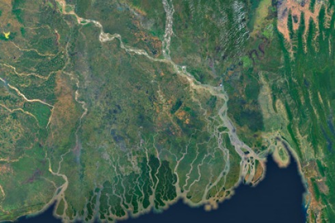
As a matter of fact, Dhaka and Kolkata are linked directly by water, as the title image by Dorothée Billard shows. The delta area presents itself to the observer as a river landscape formed by three vast rivers: the Ganges, the Meghna and the Brahmaputra. In such a “water territory”, the Buriganga and Hooghly Rivers, which are distributaries of the Meghna and the Ganges respectively, have another significance than merely being “city rivers”; and Dhaka and Kolkata in turn lose their prominent position and can be seen in this context from a different perspective. The rising of the sea level due to the climate change directly threatens West Bengal and Bangladesh, a third of its areas lie under sea level and further 10 percent only up to 1 metre above it, as described in the article by geographer Boris Braun (see p. 30). Especially in the densely populated coastal region with often weak infrastructures efficient disaster prevention and management measures are ever more needed – including the erection of better cyclone shelters, the planting of trees, and information programmes for the people. In the megacities of Kolkata and Dhaka, especially the poor are threatened as they often live in the lowest lying neighbourhoods that are most prone to flooding.
But despite all the attention “climate refugees” are receiving today in literature and public debate – migration (often seasonal) caused by geology and climate is not a new phenomenon in Bengal. Both Dhaka and Kolkata have a vast migrant populace so that in the last three decades the total number of inhabitants in both cities has surpassed the 10 millions margin. While Kolkata looks back to an at least 50-years-old tradition of strong immigrant flows coming from neighbouring Indian states and Bangladesh rather than from the city’s hinterland, urban growth in Dhaka only began much later, after the country’s independence. In 1971, only 1 million people were living in the city, in 2001, their number had increased to 10 millions.
Every day hundreds of people from the south of Bangladesh arrive at the river port of Shadar Ghat searching for work in the informal sector and hoping to build themselves a future. Often, these people settle down in immediate vicinity to the river, amidst the ecological disaster of the Hazaribagh district, the core of the recycling facilities and tanneries; on the Kamrangir Char sandbank, an island left to waste recycling; or in the vast, well established slums at the water’s edge like Karail Bosti (see p. 52). Will the future of the megacities decisively depend on their ability to create good “arrival conditions” for the seemingly irresistible mass of new immigrants, as Doug Saunders’ bestselling Arrival City suggests? At this stage, the growth in Kolkata seems to have reached a stabilised, if not decelerated state while the number of commuters and seasonal migrants is still steadily increasing. The trend that might be extrapolated from these facts seems rather to be an indicator of heightened mobility for which obviously more specific solutions must be developed.
The “unplannability” myth
All these facts raise questions concerning the strategies urban planning should follow. The ways both cities react on similar spatial and social problems – physical and social fragmentation, unregulated immigration, an enduring lack of housing, ecological challenges, and others – reflect contrasting development concepts that have up to now not produced any sustainable solutions. While in Kolkata the planning initiatives of the public sector hardly fulfil the aspirations for control of the urban phenomena and are increasingly dependent on private investment, in Dhaka gaps in the spatial and social structures remain, despite all efforts by NGOs and international cooperation agencies like the World Bank and the Asian Development Bank.
Especially with respect to cities like Dhaka and Kolkata, which have only recently changed the spelling of their names to get rid of their colonial past, we are far from imposing western planning advice. But we do not want to content ourselves with that myth of “unplannability” that is celebrating the for the most part insufficient self-organisation as the natural, and therefore favourable state. In the articles of this Stadtbauwelt issue, evidence is provided that this myth is not only an ineligible model from a social perspective but also largely incapable of coping with reality.
Translation from German by Christian Rochow


0 Kommentare